
Aerial Imaging Market Snapshot

Key Players

  • DJI Innovations (China)
  • Kespry Inc. (United States)
  • DroneDeploy (United States)
  • Parrot (France)
  • 3D Robotics (United States)
  • Microdrones (Germany)
  • Coptercam (Australia)
  • EagleView Technologies (United States)
  • Aeris Weather (United States)
  • BLOM Gruppen (Norway)

Market Size

Base Year 2024
$4.98 Bn
CAGR
13.47%
Forecast 2034
$17.62 Bn

Market Segments

By Platform Type
UAVs & Drones, Fixed-Wing Aircraft, Helicopters & Rotorcraft, Hybrid-VTOL
By Imaging Resolution
≤10 cm GSD, 10–30 cm GSD, >30 cm GSD
By Delivery Mode
Subscription Libraries, On-Demand Tasking
By Application
Geospatial Mapping & Land Survey, Disaster & Emergency Management, Agriculture & Forestry, Construction & Engineering, Others

Market Dynamics

Drivers
  • Rapid technological advancements
  • Increasing urban planning needs
Restraints
  • High operational costs
  • Legal restrictions on drone usage
Opportunities
  • Rapid urban development
  • Advancement in drone imaging technology

Market Size

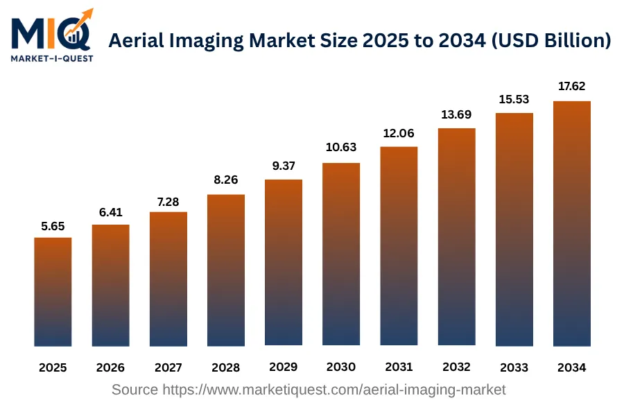
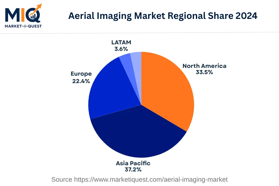
The Aerial Imaging Market was valued at $5.65 billion in 2025, growing from $4.98 billion in 2024. The market is projected to expand to $17.62 billion by 2034, at a compound annual growth rate (CAGR) of 13.5%. This significant rise stems from the increasing applications of aerial imagery in various sectors such as agriculture, forestry, and defence. Digitization trends and advancements in geospatial technology also contribute to the sector's expansion. The adoption rate of GIS and location-based services coupled with the growth in the entertainment and media industry has also driven up demand for aerial imaging. Regionally, the market shares in 2024 were distributed with Asia Pacific leading at 37.2%, followed by North America at 33.5%, Europe with 22.4%, Latin America contributing 3.6%, and the Middle East and Africa (MEA) at 3.4%.

Key Takeaways

  • By Platform Type -Fixed-Wing Aircraft held the top position accounting for a considerable market share in the base year.
  • By Imaging Resolution - 10–30 cm GSD segment led the sector with the majority share in the recent past.
  • By Delivery Mode - Subscription Libraries was the leading segment occupying a significant market position in the preceding year.
  • By Application - Construction & Engineering emerged as the leading subsegment of the segment.
aerial-imaging-market market size

Key Driving Factors

Surge in Urban Planning Initiatives

One of the significant driving factors for the aerial imaging market is the surge in urban planning initiatives. City administrations and urban planners leverage aerial imaging to create comprehensive plans, delineate land-use, and conduct environmental impact assessments. Using aerial imaging, urban developers can visualize the spatial characteristics of a region in detail, facilitating precise decision-making for development projects. Aerial images aid in identifying suitable locations for new infrastructures like transportation systems, commercial complexes, and residential buildings. It also helps in monitoring progress and ensuring adherence to regulatory requirements. This precise and efficient mapping and monitoring are pushing the adoption of aerial imaging in urban planning and development globally, thereby driving the market growth.
Inclusion of Aerial Imaging in Geospatial Data Analysis

Notably, the inclusion of aerial imaging in geospatial data analysis is another key driving factor for the market. Multiple industries like agriculture, forestry, and meteorology increasingly deploy geospatial technology. It helps in understanding patterns, relationships, and trends by correlating data from multiple sources. With high-resolution aerial images, data analysts can gain an additional level of detail, refining the precision of geospatial analysis. In agriculture, for instance, aerial imaging allows enhanced monitoring of crop health and identifying areas requiring specialized care. Such practical applications of aerial imaging in geospatial data analysis significantly elevate its market demand.

Market Evolution by Timeline

2019-2023
During this period, demand for aerial imaging mainly came from North America, specifically, the US, where real estate and construction sectors used aerial images for their planning and monitoring activities. The supply side saw improved drone technologies, increasing photo-quality and reducing drone costs. A significant policy during this era was the FAA's Relaxation on the commercial use of drones in 2016, which boosted the uptake of drones for aerial imaging. The predominant commercial model was a combination of product sales and imagery services. Risks included privacy concerns from civilian drone use and the requirement for trained personnel for operating drones.
2024
By 2024, the demand for aerial imaging spread to the agricultural sector for crop assessment and monitoring. In South East Asia, particularly India and China, the increased adoption in forestry and agriculture was noticed. Enhanced drone capabilities emerged, offering thermal and infrared sensors enhancing quality and efficiency. Policy-wise, individual country regulations regarding drone usage were normalized, simplifying cross-border operations. The tendency towards lease-based models enabled companies to access advanced tech without substantial capital investments. Challenges involved dependence on weather conditions for clear imaging, which made planned schedules unpredictable.
2025-2029
The period saw a rise in demand for aerial imagery in disaster management for assessing damage and planning rescue operations. Major demand came from disaster-prone regions like Japan and the Pacific 'Ring of Fire' countries. During this time, autonomous drones became more common, minimizing operational difficulties. Governments recognized drone-based services as vital for public safety, leading to supportive regulations. The commercial model evolved to include data analytics on top of aerial imagery. Risks included the threat of potential misuse of drones, requiring strict regulations and control measures.
2030-2034
In these years, defense and law enforcement emerged as key sectors demanding aerial imaging for surveillance, crime scene investigation, and peace-keeping missions. Middle-East and African nations prominently using this technology due to increased conflict situations. Supply saw a shift towards AI-integrated drones capable of real-time imaging and analytics. Internationally accepted drone standards solidified, and privacy regulations were rigorously implemented to address concerns. The commercial model shifted towards a comprehensive service model, combining aerial imaging, real-time analytics, and consulting. Protective measures against drone misuse became critical for maintaining privacy and safety.

Future Market Outlook

Future Opportunities

The future of the aerial imaging market is poised for expansion, largely influenced by current regulatory contexts and emerging technological applications in various sectors. For example, the implementation of the European Union’s U-Space initiative aims to create a regulatory framework for safer drone operations within urban airspaces, which is expected to enhance the utility of aerial imaging services in crowded environments. Additionally, the construction sector, which is increasingly adopting Building Information Modeling (BIM), presents opportunities for aerial imaging to provide real-time updates and site evaluations, as construction projects are becoming more digitally integrated. In the environmental sector, ongoing global initiatives focused on climate change are likely to drive demand for remote sensing technologies, as countries look to monitor deforestation and land use changes more effectively. The potential for aerial imaging in disaster response is also gaining traction, with agencies like FEMA emphasizing the importance of post-disaster damage assessments, creating demand for rapid aerial surveys. Furthermore, collaborative efforts between tech firms and agricultural stakeholders are paving the way for tailored aerial imaging solutions to monitor crop health. These developments indicate that the convergence of advanced imaging technologies with supportive regulations will likely create a fertile landscape for diverse applications in the coming years.

Segmentation Analysis

By Platform Type

The market is divided into subsegments including UAVs & Drones, Fixed-Wing Aircraft, Helicopters & Rotorcraft, and Hybrid-VTOL. Among these, Fixed-Wing Aircraft accounted for the largest revenue share while UAVs & Drones are expected to grow at the fastest CAGR during the forecast period.

Largest Revenue Share

Fixed-Wing Aircraft

Market Share Leader

Fixed-Wing Aircraft hold the largest market share largely due to their extensive use in both commercial and military applications. These aircraft are primarily preferred due to their long-range capability, speed, and ability to carry a considerable payload, making them ideal for multiple mission types. Commercial aviation heavily relies on these aircraft for passenger and cargo transportation worldwide, while the military uses them for reconnaissance, surveillance, and combat missions. Regulations in most geographies permit the use of these aircraft, contributing to their strong market presence. The purchasing criteria for fixed-wing aircraft are often determined by factors such as cost-effectiveness, mission adaptation, and operational efficiency. There exist significant barriers to switching given the substantial investment in dedicated infrastructure, staff training and safety regulations, further securing their market position. Sales channels commonly used for distribution include direct sales and partnerships with governments, for both which Fixed-Wing Aircraft sees strong demand.

Fastest CAGR

UAVs & Drones

Forecast Period Growth Leader

The UAV & Drones subsegment is expected to witness the fastest growth. This anticipated acceleration stems from the increasing adoption of this technology across multiple industries. Industries such as agriculture, real estate, and disaster response services have begun to harness the potential of these devices in tasks like crop monitoring, aerial photography, and emergency relief operations, driving their rapid market growth. Despite the current barriers to adoption – such as restrictive regulations in certain geographies and high initial investment – the potential future policy easing and new technology partnerships are likely to lower these barriers significantly. One must consider risks associated with the disruptive nature of this technology, including potential regulatory changes and volatility in investment. Nevertheless, the increasing capital expenditure on research and development, coupled with the ongoing technology advancements, augur well for the UAV & Drones subsegment's growth outlook.

By Imaging Resolution

The market is divided into subsegments including ≤10 cm GSD, 10–30 cm GSD, and >30 cm GSD. Out of these, the 10–30 cm GSD subsegment accounted for the largest revenue share, while >30 cm GSD is expected to grow at the fastest CAGR during the forecast period.

Largest Revenue Share

10–30 cm GSD

Market Share Leader

The 10–30 cm GSD subsegment carved out the biggest piece of the pie in 2024 due to several driving factors. Firstly, this resolution fits a wide range of applications, from military operations to agricultural monitoring, without incurring excessively high data processing costs. High enough to retain satisfactory detail levels and ensure flexible usability, this is a functional compromise between the ultra-high detail of ≤10 cm GSD, which is substantially more expensive, and the lower resolution detail of >30 cm GSD. Coupled with the shifting purchasing criteria that focus on cost-efficiency and interoperability, the 10–30 cm GSD sector has risen to prominence. This subsegment is also propelled by specific geographical needs and regulatory approvals, primarily in developed nations where moderate level imaging resolution facilitates urban planning and infrastructure development, among other things.

Fastest CAGR

>30 cm GSD

Forecast Period Growth Leader

The >30 cm GSD subsegment is forecasted to experience the most robust CAGR in the coming years. An essential catalyst propelling the growth of this subsegment is technological advancements, particularly in capturing broader area coverages and the adoption of machine learning techniques for image analysis. Budget limitations of many prospective satellite imagery customers, particularly in emerging economies, also swing the pendulum towards >30 cm GSD. Partnership strategies with end-user industries and regional governments are expected to break down adoption barriers and stimulate further growth. Nevertheless, near-term risks such as stiff competition and stringent regulatory compliances could pose challenges to this rapid growth. Understanding these dynamics is crucial for businesses to make informed decisions and leverage growth opportunities in this market segment.

By Delivery Mode

The market is divided into subsegments including Subscription Libraries and On-Demand Tasking. In the base year of 2024, Subscription Libraries accounted for the largest revenue share while On-Demand Tasking is expected to grow at the fastest CAGR during the forecast period.

Largest Revenue Share

Subscription Libraries

Market Share Leader

Subscription Libraries have risen to paramount importance largely due to their structuring which provides users with unlimited access to a range of tools, resources, and services for a periodic fee, delivering a high-value solution for many businesses. This model is popular amongst industries seeking cost-effective solutions amidst a burgeoning technological landscape filled with complex pricing models and hidden costs. The revenue growth of Subscription Libraries is driven by several factors, including customer purchasing criteria favoring predictable cost structures, low switching costs due to multi-vendor situations, and the ease of deploying digital services across diverse geographies. Subscription Libraries have benefited from a wide array of regulations in various countries supporting digital services, and the ability to use remote channels for service delivery, thereby increasing their market reach.

Fastest CAGR

On-Demand Tasking

Forecast Period Growth Leader

On-Demand Tasking subsegment is set for a steep growth trajectory, potentially at a faster rate than any other subsegment. This can be attributed to the growing need for businesses to accomplish tasks and projects in real-time, as and when the requirement arises. Its operational flexibility makes it a highly favorable option, mostly for businesses operating in dynamic and rapidly evolving markets. The adoption barriers for On-Demand Tasking are minimal, largely due to the increasing digitalization and subsequent readiness of businesses to adopt digital solutions. Regulatory policies are reflecting a global consensus on digitalization acceleration, which sets a favorable environment for On-Demand Tasking. However, its reliance on the stability and availability of digital infrastructure poses near-term risks, especially in regions where technological infrastructure is erratic or underdeveloped.

By Application

The market is divided into subsegments including Geospatial Mapping & Land Survey, Disaster & Emergency Management, Agriculture & Forestry, Construction & Engineering, and Others. Among these, Construction & Engineering accounted for the largest revenue share while Agriculture & Forestry is expected to grow at the fastest CAGR during the forecast period.

Largest Revenue Share

Construction & Engineering

Market Share Leader

The Construction & Engineering sector emerges as the predominant revenue generator among the applications in 2024. This dominance is driven by the increasing adoption of advanced technology in the construction industry, augmented by the rising demand for high-quality, accurate, and timely project deliverables. Adhering to regulatory compliance, cost efficiency, and risk mitigation are significant drivers for the implemention of geospatial solutions in the construction and engineering fields. High capital investments in infrastructure projects worldwide, especially in developing economies, contribute heavily to this demand. Adoption of these solutions allows companies to monitor project progress meticulously, reducing error rates, and improving productivity. The presence of established distribution channels and partnerships with technology providers further facilitates the growth and revenue share of this subsegment.

Fastest CAGR

Agriculture & Forestry

Forecast Period Growth Leader

The Agriculture & Forestry subsegment is projected to exhibit the fastest growth in terms of CAGR. Key factors driving this growth include rapid technological advancements and growing awareness about the benefits of geospatial data in improving agricultural productivity and forest management. The adoption of precision agriculture and digital farm management solutions are becoming more mainstream, thereby boosting the use of geospatial solutions. Moreover, government initiatives to promote sustainable farming practices and manage forestry resources more effectively are anticipated to further fuel market growth in this subsegment. However, high implementation costs and lack of technological expertise may pose as significant barriers to adoption, especially in developing regions. Therefore, industry players and policy makers need to focus on reducing these barriers to ensure continued growth in the market.

Competitive Analysis

Key Market Players

Manufacturers / OEMs

Blom ASA
Norway
EagleView Technologies
US
GeoVantage
US

Key Suppliers & Raw Materials

Trimble Inc.
US
Harris Corporation
US
BAE Systems
UK

Distributors, Integrators & Channel Partners

Land Info Worldwide Mapping LLC
US
Nippon Computer Dynamics
Japan
AAM Pty Ltd
Australia

Porter’s Five Forces Analysis

An evaluation of the competitive dynamics within the aerial imaging market.

Supplier Bargaining Power

Medium

Dependent on technology providers, OEMs but diversified due to multiple hardware and software options.

Buyer Bargaining Power

High

Buyers have numerous providers to choose from, thereby increasing their bargaining power.

Threat of Substitutes

Low

No direct substitutes exist, however alternative imaging technologies pose a minor threat.

Threat of New Entrants

Medium

Technology advancements and reduced entry cost foster new competitors, but regulatory barriers exist.

Competitive Rivalry

High

Intense competition due to numerous players offering similar services.

Regional Analysis

Geographic market dynamics and growth opportunities across key regions

Global Market Outlook

aerial-imaging-market market regional share

North America

In 2024, the North American Aerial Imaging Market demonstrated noteworthy growth driven by numerous factors. Increased adoption of aerial imaging technologies by the real estate and construction industries played a significant role, driven by the demand for accurate and extensive data. Furthermore, the push from governmental regulations in the U.S., Canada, and Mexico for more comprehensive geographical data collection amplified the demand. The adoption of advanced technologies, specifically LIDAR (Light Detection and Ranging), defined the prevailing market trends, particularly within the environmental and archeological sectors. Industries increasingly opted for drone-based aerial imaging services, a shift notably reflected in the significant uptake by the agricultural sector in the U.S. and Canada to enhance crop monitoring.

In addition, the year was marked by several key partnerships and M&A activities; tech giants such as Google and Apple integrated aerial imaging services to augment their mapping solutions. Standards to ensure the quality and accuracy of aerial imaging data also began to take shape, led by policy enforcement in the U.S. The predominant customers of this market in 2024 were government, real estate, agriculture, and environmental sectors, driven by the need for precise location-based data. Notably, the retail and enterprise sectors also started seeking these services for logistics and delivery planning. The robust growth in this market was a testament to the increased reliance on precision and efficiency across sectors.

Asia Pacific

In 2024, the Aerial Imaging Market in Asia Pacific was notably driven by accelerated application across key sectors including government, manufacturing, and retail. Favorable government regulations fostered market expansion, as did significant technological advancements which made aerial imaging more accessible and affordable. Intense investment in infrastructure and utilities across China, India, and key ASEAN markets further boosted demand for detailed aerial data. Lastly, supply dynamics played a role, with a surge in drone suppliers improving market accessibility and directly influencing pricing in Japan and Australia.

On the trends side, buyer preferences veered towards integrated solutions, prompting manufacturers to offer comprehensive imaging packages. Increased adoption of AI technology in aerial imaging became evident, improving data analysis and interpretation. Channel dynamics were shaped by strategic partnerships in South Korea, China, and India, offering value to both manufacturer and consumer. Mergers and acquisitions were particularly prevalent in China. A noteworthy trend was the enforcement of stricter drone usage policies across major countries in Asia Pacific, significantly impacting the operational framework. This highlighted a major pivot towards regulatory compliance in the realm of aerial imaging. It's also noteworthy to mention the increasing usage of aerial imaging in healthcare, as seen through disease tracking in India. Meanwhile, in Australia, aerial imaging technology was extensively used to manage and observe extensive utilities infrastructure. In essence, both market drivers and strategic maneuvers governed the Aerial Imaging Market in 2024.

Europe

In 2024, the European Aerial Imaging Market was significantly diverse, driven by increasing technological adoption and rising demand in fields such as real estate, construction, and agriculture. Faster internet speeds and rising drone usage played significant roles in accelerating its expansion. In addition, a newly introduced European Union drone regulation spurring responsible tech adoption catalysed market growth. German investments in green energy projects demanded accurate aerial imagery for mapping and planning, amplifying market activity. In parallel, British local governments extensively employed aerial imaging for environmental monitoring and urban planning purposes, fostering market dynamism.

Notable trends included shifting buyer behaviours with businesses (specifically real estate and utilities sectors) increasingly relying on aerial imaging for detailed analysis and decision-making. Governments and environmental organisations in the Nordics were similarly swayed, leveraging aerial photos to monitor climate changes. Moreover, a wave of strategic partnerships took centre-stage, as seen in France and Italy with technology firms collaborating with government entities to foster market growth. Additionally, technological developments marked a pivotal turn, marked by Spain's adoption of advanced 3D aerial imaging for infrastructure planning. Simultaneously, in Central and Eastern Europe, the focus on digital transformation in sectors like agriculture and manufacturing increased demand, bringing an encouraging dynamism to the aerial imaging landscape.

Latin America

In 2024, the aerial imaging market in Latin America experienced substantial growth driven by various factors. Technological adoption was prominent as investment in advanced imaging technologies such as drones increased in key countries. Brazil, leading this trend, saw considerable enterprise investment in drone technology, primarily for agricultural sector applications. Meanwhile, Mexico saw a rise in government spending for aerial imaging services in urban planning and infrastructure development.

The market was also shaped by regulations. In Colombia, the implementation of clear guidelines for drone usage boosted the adoption of aerial imaging in industries such as surveillance and real estate. Price dynamics were another significant driver. In Argentina, Chile, and Peru, the declining costs of imaging services led to increased demand from small and medium-sized businesses.

In terms of trends, there was a noticeable shift in buyer behavior across the region, with an increased preference for high-resolution imagery services. This was largely seen in sectors such as utilities and manufacturing. A significant trend was the rising number of partnerships and M&A activity notably in the retail sector, with firms in Brazil and Mexico investing in aerial imaging technology for inventory management. Lastly, policy enforcement played a major role in 2024, with strict data privacy rules implemented across the region influencing the methods and types of aerial imaging used, especially within the healthcare and government sectors.

Middle East & Africa

In 2024, the Aerial Imaging Market in the Middle East and Africa exhibited significant growth dynamics due to an amalgamation of demand factors, technological developments, and strategic alliances. Drivers of the market included increasing demand from government and utility sectors for infrastructure planning, along with the private sector's adoption of aerial imaging to gain competitive advantage. Strict regulations and substantial investment in digitalization, notably by Saudi Arabia, UAE, and Israel, further enhanced technology adoption rates across the region.

Heightened security concerns in affected countries like Nigeria and Egypt also led to an increased uptake of aerial imaging technology for surveillance purposes. Market trends witnessed a shift towards the adoption of drones for aerial imaging, stimulated by their cost-effectiveness and feasibility over traditional methods. In South Africa and Kenya, for instance, drone technology was gaining prominence in wildlife conservation efforts. The oil and gas sector, particularly Qatar, UAE, and Saudi Arabia, leaned towards aerial imaging for exploration and pipeline monitoring tasks, thereby driving volume sales. An emergent trend was the blossoming partnerships between key imaging providers and local industry players to establish a firm market presence and cater to the burgeoning demand. In the telecom sector, elevated demands for improved network planning was a noteworthy trend throughout the region. These factors shaped the aerial imaging landscape across the Middle East and Africa during the base year.

Recent Industry Developments

Latest market innovations, product launches, and strategic initiatives

June 2026

ALTUS LSA and Gremsy formally executed a Memorandum of Understanding (MoU) during the Eurosatory 2026 defense exhibition in Paris. The alliance is structured to systematically integrate Gremsy's advanced VIO multi-sensor camera payloads into ALTUS LSA's specialized unmanned aerial platforms, driving high-resolution visual and thermal aerial intelligence across the European public safety and industrial inspection sectors.

Frequently Asked Questions